the Creative Commons Attribution 4.0 License.
the Creative Commons Attribution 4.0 License.
 | 11 Jul 2025
Global analysis of in situ cosmogenic 26Al and 10Be and inferred erosion rate ratios in modern fluvial sediments indicates widespread sediment storage and burial during transport
Paul R. Bierman
Alexandru T. Codilean
Lee B. Corbett
Marc W. Caffee
Since the 1990s, analysis of cosmogenic nuclides, primarily 10Be, in quartz-bearing river sand has allowed the quantitative determination of landscape mass loss rates (hereafter, erosion rates) at a basin scale. Paired measurements of in situ cosmogenic 26Al and 10Be in sediment are less common but offer insight into the integrated exposure and burial history of sediment moving down slopes and through drainage basins. Prolonged burial (>105 years), a violation of assumptions underlying erosion rate calculations, is indicated by higher 26Al-based than 10Be-based erosion rates due to preferential loss of shorter-lived 26Al by decay when quartz is at least in part shielded from cosmic rays.
Here, we use a global compilation of 26Al and 10Be data generated from quartz-bearing fluvial sediment samples (n=766, including 117 new measurements) to calculate the discordance between erosion rates derived from each nuclide. We find that over 30 % of samples (n=234) exhibit discordance (>2σ analytical uncertainty) between erosion rates derived from 10Be and 26Al, indicating sediment histories that include extended burial during residence on hillslopes and/or in the fluvial system after or during initial near-surface exposure. Physical basin parameters, such as basin area, slope, and tectonic activity, exhibit significant correlation with erosion rate discordance, whereas climatic parameters have weak correlation, allowing us to infer the likelihood of sediment burial during transport in different geomorphic settings.
Paired 26Al and 10Be analyses in detrital fluvial samples provide a window into watershed processes, elucidating landscape behavior at different spatial scales and allowing a deeper understanding of both sediment routing systems and whether methodological assumptions are violated. Although previous studies have found erosion rate discordance to be common in the world's largest drainage basins, our analysis suggests that such discordance also occurs regularly in basins as small as 1000 km2, indicating that sediment storage mechanisms are more complex than suggested by simple floodplain area scaling laws. Moderately sized basins (1000–10 000 km2) with low average slopes in tectonically quiescent terrains appear conducive to extended sediment storage; thus, erosion rates from such basins are lower limits due to nuclide decay during storage. We find that sediment sourced from smaller, steeper basins in tectonically active regions is more likely to have similar 10Be and 26Al erosion rates indicative of limited storage and is thus more likely to provide reliable erosion rates.
- Article
(3846 KB) - Full-text XML
-
Supplement
(1314 KB) - BibTeX
- EndNote


Fluvial sediments are a rich source of information about the upstream sediment routing system, which encompasses sediment generation, transport, and storage processes (Romans et al., 2016; Tofelde et al., 2021). For example, in situ cosmogenic 10Be measurements of quartz isolated from fluvial sediments are used to estimate basin-averaged erosion rates. The application of this method in thousands of drainage basins around the world has provided valuable insights into physical and climatic controls on erosion (von Blanckenburg, 2005; Codilean et al., 2022; Portenga and Bierman, 2011; Schaefer et al., 2022). Such analyses assume an upstream sediment history in which material was generated through steady exhumation on hillslopes and then transported rapidly through fluvial networks, experiencing negligible storage while in transit (Bierman and Steig, 1996; von Blanckenburg, 2005; Granger et al., 1996; Granger and Schaller, 2014; Schaefer et al., 2022). Although erosion rates are now commonly measured, few studies have assessed the underlying assumptions of the technique and how often those assumptions are violated.
Sediment grains in fluvial systems can have a wide range of idiosyncratic transport and storage histories potentially spanning more than 106 years in large basins, as shown by cosmogenic nuclide analyses in modern fluvial sediments (Fülöp et al., 2020; Repasch et al., 2020; Wittmann et al., 2011), volumetric and geochemical analyses of valley fills (Blöthe and Korup, 2013; Jonell et al., 2018; Munack et al., 2016), and sediment transport models (Carretier et al., 2020). These complex sediment histories, along with the protracted sediment lag times, may confound reliable interpretation of upstream processes (Allen, 2008; Jerolmack and Paola, 2010). Sediment samples used for analysis of cosmogenic nuclides are typically amalgamations of thousands of grains, each of which has its own unique history.
Measuring multiple in situ cosmogenic radionuclides with different half-lives is a promising approach for discerning fluvial sediment histories (Codilean and Sadler, 2021; Schaefer et al., 2022). Calculating ratios between multiple cosmogenic radionuclides has provided insight into sediment provenance (e.g., Cazes et al., 2020) and storage histories (e.g., Wittmann et al., 2011; Fülöp et al., 2020; Ben-Israel et al., 2022) in river systems around the world. Such studies have helped test hypotheses about sediment dynamics in river basins, including that the integrated storage duration experienced by sediments on hillslopes and in floodplains is generally greater in larger basins (Wittmann et al., 2020), in post-orogenic regions (Cazes et al., 2020; Struck et al., 2018), and in arid regions (Makhubela et al., 2019). However, such hypotheses have yet to be tested on a global scale, and questions remain, such as whether sediment storage duration scales with physical and/or climatological basin metrics.
In this study, we compiled measurements of paired in situ 26Al and 10Be concentrations in detrital fluvial sediment from around the world (n=766, including 117 new 26Al measurements on archived samples with previously published 10Be measurements) to test for the existence and likelihood of fluvial sediment storage across a wide range of physical and climatological drainage basin settings. We account for localized differences in nuclide production ratios to facilitate comparison across the world and use a variety of statistical tests to assess relationships between isotope concentrations and basin-scale landscape and climate parameters. Such a global description provides insight into the complexity of river sediment transport and storage and allows us to evaluate the validity of assumptions inherent to the widely used, basin-scale cosmogenic nuclide erosion rate method (von Blanckenburg, 2005; Granger and Schaller, 2014; Schaefer et al., 2022).
2.1 Sediment system dynamics and landscape change
Fluvial sediments are products of hillslope processes and are moved through sediment routing systems. These systems generally encompass regions of net sediment generation through bedrock weathering, regolith production, and sediment export from hillslope source zones (Allen, 2017). This detrital material is then transported by fluvial systems through riverine transfer zones and deposited in detrital sink zones (Schumm, 1977). Depending on the geometry of the riverine transfer zone, sediment storage may be transient (e.g., steep bedrock streams) or long-lasting (e.g., lowland alluvial rivers). The extent and duration of storage in floodplains and sedimentary basins is an important control on weathering (e.g., Campbell et al., 2022; Dosseto et al., 2014) and on both the production of cosmogenic nuclides in sediments near the surface and the decay of those radionuclides if sediment is buried (Lal, 1991).
Understanding rates, controls, and dynamics of sediment generation and transport is important for quantifying landscape change over time and space (Allen, 2008; Romans et al., 2016). In many routing systems, river morphology (Langbein and Leopold, 1964; Leopold and Wolman, 1960) and floodplain volume (e.g., Otto et al., 2009) are determined by the sediment mass flux out of source zones, the rate of transit through transfer zones, and the accommodation space available for sediment storage. Changes to rates of sediment generation or transfer, primarily driven by tectonic or climatic forcings (Romans et al., 2016), can thus affect the behavior of both sediment-supplying hillslopes and riverine transfer zones. Identifying such changes over space and through time is an important objective of geomorphological research and has prompted the development of tracer and rate-determining detrital geochronological methods, including measurements of cosmogenic nuclides, fission tracks, fallout radionuclides, and in various mineral phases (Allen, 2017).
2.2 Interpreting landscape processes from cosmogenic nuclides
The application of cosmogenic nuclide analyses to fluvial sediments, firstly using single nuclides (Bierman and Steig, 1996; Brown et al., 1995; Granger et al., 1996) and later paired nuclides (e.g., Clapp et al., 2000, 2001), has significantly advanced our understanding of geomorphology and sediment routing systems at a variety of spatial and temporal scales (e.g., Bierman and Nichols, 2004; von Blanckenburg, 2005; Codilean et al., 2021; Portenga and Bierman, 2011; Willenbring et al., 2013; Wittmann et al., 2020). Key to the interpretation of measured nuclide concentrations is a quantitative understanding of nuclide production and decay rates throughout the basin from which the sediment is derived.
The ratio of 26Al to 10Be at production is ∼6.8 at low and mid-latitudes (Balco et al., 2008), but there are subtle influences of latitude and altitude on that ratio (Argento et al., 2015; Halsted et al., 2021; Lifton et al., 2014). Nuclide production decreases exponentially with depth below Earth's surface such that, once sediment is buried more than 1–2 m, decay, rather than production systematics, controls the evolution of the ratio over time (Granger, 2006; Wittmann and von Blanckenburg, 2009).
Landscapes lose mass by both chemical and physical processes. The sum of these processes is referred to as denudation and includes total mass loss integrated over depth. Mass loss rates inferred from cosmogenic nuclide concentrations in sediment have most often been referred to as erosion rates (Bierman and Steig, 1996; Granger et al., 1996; Lal, 1991; VanLandingham et al., 2022), and we adopt that convention in this paper. We do this because our dataset includes numerous samples from parts of the world where there is deep chemical weathering (the tropics and unglaciated, low-slope temperate regions). In these areas, mass loss through dissolution and groundwater export extends many meters below the penetration depth of the cosmic ray neutrons responsible for most 10Be and 26Al production. Such export of mass in solution is not reflected in the concentration of in situ-produced cosmogenic nuclides, which are only sensitive to mass loss in the uppermost few meters of Earth's dynamic surface (e.g., Campbell et al., 2022).
2.2.1 Basin-scale erosion rates from single-nuclide measurements
Basin-scale erosion rates have been estimated around the world by measuring the concentration of a single cosmogenic nuclide, most often in situ 10Be, in samples of amalgamated river sediment (Bierman and Steig, 1996; Brown et al., 1995; Codilean et al., 2022; Granger et al., 1996; Portenga and Bierman, 2011). Sediment grains accumulate 10Be during exhumation and at the surface in source zones, with the nuclide concentration within grains being proportional to the residence time of grains on hillslopes (Heimsath et al., 1997; Jungers et al., 2009). When collecting a sample of fluvial sediment downstream, it is assumed that such a sample represents the average nuclide concentration in grains sourced from all sediment-generating hillslopes within a basin (Bierman and Steig, 1996; Granger et al., 1996; Brown et al., 1995).
Accuracy of basin-scale erosion rate calculations depends upon the validity of several assumptions about sediment generation and transport that cannot be tested with single-nuclide analyses: that sampled grains were steadily exhumed on hillslopes in sediment source zones, are well mixed, and are transported rapidly through fluvial networks such that nuclide production and decay in the transport zone are minimal (Bierman and Steig, 1996; Granger et al., 1996; Brown et al., 1995). This last assumption is most likely to be valid if the volume of sediment stored in the system is small in comparison to the volume of sediment generated and transported through the system on timescales relevant to 10Be production and decay (millennia; Granger et al., 1996).
2.2.2 Sediment routing dynamics from paired 10Be and 26Al
In situ 10Be and 26Al are the most commonly analyzed cosmogenic nuclide pair in river sediment, with measurements having started in the late 1990s (Bierman and Caffee, 2001; Clapp et al., 2000, 2001, 2002; Heimsath et al., 1997; Nichols et al., 2002). Their popularity reflects the relative ease of extracting this isotope pair from the same aliquot of quartz, the wide distribution of quartz across landscapes, and their contrasting half-lives (1.4 and 0.7 Myr, respectively; Chmeleff et al., 2010; Korschinek et al., 2010; Nishiizumi, 2004). When sediment is buried, the shorter-lived 26Al is preferentially lost as decay exceeds production, and the ratio in quartz lowers over time (Balco and Rovey, 2008; Granger, 2006).
ratios lower than those at production have been used as isotopic indicators of sediment storage and subsequent remobilization in catchments across the world, ranging from arid (Bierman et al., 2001; Bierman and Caffee, 2001; Clapp et al., 2002; Kober et al., 2009) to tropical (Campbell et al., 2022; Wittmann et al., 2011) climates and in small (Clapp et al., 2000, 2001) to very large (Ben-Israel et al., 2022; Fülöp et al., 2020; Hidy et al., 2014; Wittmann et al., 2020; Wittmann and von Blanckenburg, 2016) basins. However, in some studies, lowered ratios were attributed to laboratory errors (Insel et al., 2010; Walcek and Hoke, 2012; Hattanji et al., 2019) or incorporation of meteoric 10Be (Corbett et al., 2022; Moon et al., 2018) and were disregarded.
In this study, sediment burial (and resulting preferential loss of shorter-lived 26Al by decay) is reflected by the discordance between erosion rates calculated from 10Be (EBe) and 26Al (EAl), the calculation of which normalizes spatial variations in the surface production ratio and accounts for differential nuclide decay during prolonged surface exposure in very slowly eroding terrains. Thus, calculating erosion rate discordance rather than using nuclide concentration ratios facilitates comparisons between basins across the world and is sensitive only to nuclide decay caused by sediment burial after initial exposure, rather than decay that occurs during prolonged surface or near-surface exposure.
If sediment is transferred from slopes into channels and transported through the channel network without extended burial, then erosion rates calculated from the concentration of each nuclide should be coincident (EBe=EAl). Discordance between erosion rates calculated from the two nuclides (unless it is caused by laboratory errors) reflects preferential loss of 26Al when and where decay exceeds production, in which case EBe<EAl. This occurs when sediment is stored below the surface (>2 m) and for extended periods (>105 years) after initial surface exposure on hillslopes or in floodplains (Fig. 1).
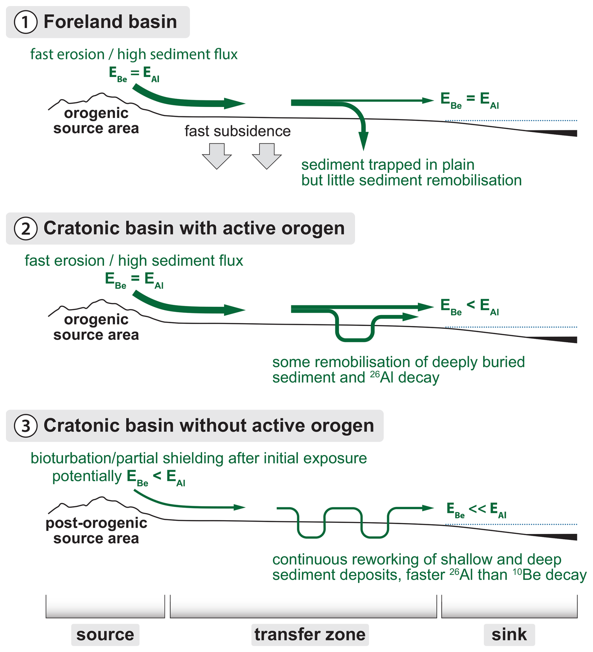
Figure 1Effects of storage in sediment source and/or transfer zones on 10Be- and 26Al-based erosion rates measured in detrital quartz grains. In panel (1), rapid erosion rates in the source zone and limited remobilization of stored sediment in the transfer zone result in detrital sediment with concurrent erosion rates (). In panel (2), rapid erosion rates in the source zone and some remobilization of stored sediment in the transfer zone result in detrital sediment with erosion rate discordance (), although prolonged sediment storage (>105 years) is necessary for erosion rate discordance to be measurable. In panel (3), slow erosion rates in the source zone and remobilization of stored sediment in the transfer zone result in detrital sediment with substantial erosion rate discordance (). This figure is based on Fig. 6 in Wittmann et al. (2016).
Floodplain sediment storage of <105 years has minimal effect on in sediment grains (Wittmann and von Blanckenburg, 2009), but, during prolonged (>105 years) storage, especially at depths below which most nuclide production by spallation occurs (> several hundred g cm−2), the of amalgamated samples can lower sufficiently that the lowering can be detected with confidence in quartz containing moderate to high concentrations of these nuclides (Fig. 1). In slowly eroding terrains (<10 m Myr−1), long subsurface sediment residence times on hillslopes after initial exposure, due to vertical mixing, can lead to erosion rate discordance in sediment source areas due to preferential 26Al decay before regolith reaches the channel (Fig. 1; Makhubela et al., 2019; Struck et al., 2018). The rate of lowering is depth-dependent: the ratio decreases more rapidly with increased sediment burial depth as nuclide production rates decrease.
Re-introduction of stored sediment with low back into the active channel will lower the average of fluvial sediment in transport (Wittmann et al., 2009; Fig. 1). Geomorphic processes responsible for sediment reworking in transfer zones vary widely depending on basin morphology, tectonics, and climatology. Extensive sediment storage followed by remobilization is documented in meandering, low-lying tropical river systems (Wittmann et al., 2011); arid river systems that source sediment from sand dunes containing long-buried sediments (Eccleshall, 2019; Vermeesch et al., 2010); hydrologically variable basins where flood events remobilize vertically accreted floodplain deposits (Codilean et al., 2021); and formerly glaciated basins where sediments were repeatedly covered by ice (Jautzy et al., 2024). While old, deeply buried deposits typically have low nuclide concentrations and thus less influence on the average when mixed with active channel sediment in small amounts, high-flow events may remobilize substantial volumes of long-buried sediment and have a significant impact on nuclide concentrations (e.g., Codilean et al., 2021; Wittmann et al., 2011) and calculated .
3.1 Study design – approach and limitations
In this study, we use a compilation of previously published (n=649) and new (n=117) paired 10Be and 26Al concentration measurements in fluvial sediments to assess storage and remobilization during sediment generation and/or transport. We calculate nuclide-specific erosion rates and use the agreement or discordance between these rates to identify burial during transport. We measure the morphometric and climatological properties of basins from which the sampled sediments derive and use a variety of statistical analyses to assess if basin properties are correlated with cosmogenic indications of burial. Then, we consider geomorphic mechanisms to explain observed correlations and discuss the implications of our results for the widely used basin-averaged 10Be erosion rate method.
Measured 26Al and 10Be alone cannot quantify sediment storage durations or identify specific geomorphic histories for each sample because sediment samples are mixtures of grains with different histories and the inverse solutions are non-unique (Bierman and Steig, 1996; von Blanckenburg, 2005; Brown et al., 1995; Granger et al., 1996; Schaefer et al., 2022). The rate of lowering in stored sediment is depth-dependent (Wittmann and von Blanckenburg, 2009); thus, the mixing of grains with different storage depth and time histories, and consequently varying histories and duration of nuclide decay and production, precludes accurate estimations of storage duration. Although we identify basin properties that correlate with isotopic indications of burial and storage, the identification of specific processes responsible for storage and subsequent remobilization will differ on a case-by-case basis.
3.2 Data sources
We used two data sources: measurements in reported published studies (n=649) and 26Al and 10Be concentrations from new 26Al measurements made on samples archived at the University of Vermont (UVM) that had previously published 10Be concentrations (n=117). For all samples, we normalized originally reported 10Be concentrations to the 07KNSTD standard (Nishiizumi et al., 2007) and 26Al concentrations to the KNSTD standard (Nishiizumi, 2004) using conversion factors based on the original accelerator mass spectrometry (AMS) standards used for normalization (Table S1 in the Supplement; Balco et al., 2008; Nishiizumi et al., 2007).
3.2.1 Sources of previously published paired 26Al and 10Be measurements
We sourced data from the OCTOPUS database (Codilean et al., 2018, 2022; Codilean and Munack, 2025) for previously published paired 26Al and 10Be measurements from fluvial sediments around the world with robust documentation of processing methods, including the Al and Be standards used during AMS measurements (n=555). We also compiled samples from studies that had not yet been added to the OCTOPUS database at the time of writing (n=94; Wang et al., 2017; Adams and Ehlers, 2018; Mason and Romans, 2018; Moon et al., 2018; Hattanji et al., 2019; Hubert-Ferrari et al., 2021; Yang et al., 2021; Zhang et al., 2021, 2022; Ben-Israel et al., 2022; Jautzy et al., 2024). Previously published samples were processed at numerous laboratories, including at UVM, and were analyzed at several AMS facilities (sources, raw data, and AMS facilities for previously published samples are reported in Table S1).
3.2.2 Sample processing for new 26Al measurements
Samples with new 26Al measurements come from a wide range of locations but were processed entirely at UVM between 2009 and 2019. These archived samples had previously undergone Be and Al extraction following established methods (Corbett et al., 2016) but only had 10Be concentrations measured (10Be concentration measurements were originally reported in their source publications and are provided in Table S2 in the Supplement). The Al-bearing fraction of these archived samples, Al and Be having been separated by column chromatography during the original sample processing for 10Be analysis (Corbett et al., 2016), was stored as Al hydroxide gels.
We re-dissolved the gels into a chloride liquid form using 1 mL of 6 mol L−1 hydrochloric acid and allowed the gels to sit in acid for several weeks. When completely dissolved, we added 4 mL of water to each sample to create a 1.2 mol L−1 hydrochloric acid solution for column chromatography and centrifuged the samples to remove any lingering undissolved material. We removed 26Mg, an isobar of 26Al, via column chromatography and then followed the methods outlined in Corbett et al. (2016) to convert samples into an Al oxide powder mixed with Nb for measurement via accelerator mass spectrometry (AMS).
ratios for these re-processed samples were measured using AMS between 2019 and 2021 at the Purdue Rare Isotopes Measurement Laboratory (PRIME), where the addition of a gas-filled magnet to the AMS has significantly reduced 26Al measurement uncertainties (Caffee et al., 2015). Samples were measured against the primary standard KNSTD with a ratio of (Nishiizumi, 2004). We re-processed blanks that were archived with the Al hydroxide gels from their original processing batches (n=37) and blank-corrected samples by subtracting the estimated 26Al atoms in the batch-specific blank from the total 26Al in the sample (Table S2). Where the original batch blank was missing, likely due to others re-sampling Al gels from the batch prior to 2019, the average ratio from all re-processed blanks (2.37 ± ; 1 SD) was used to estimate a blank correction. We propagated AMS and blank measurement uncertainties in quadrature to quantify total 26Al concentration uncertainty. All new 26Al concentration, blank, and uncertainty measurements and calculations can be found in Table S2.
3.3 Calculating 10Be- and 26Al-derived erosion rates and erosion rate discordance
We use the erosion rate calculator formerly known as CRONUS v3 (Balco et al., 2008) with the nuclide-specific LSDn scaling scheme (Lifton et al., 2014) to calculate EB and EAl. The LSDn scaling scheme depicts spatial variations in the surface production ratio (Halsted et al., 2021); thus calculated EB and EAl values are normalized to local nuclide-specific production rates to facilitate comparisons across the world. We assumed no shielding and estimate spatially averaged basin altitude scaling factors using an iterative process that identifies the atmospheric pressure value best matching the spatially averaged Lal/Stone production rate in each basin, a more computationally efficient method than pixel-based approaches for this large compilation and with nearly indistinguishable results (Codilean and Munack, 2025). We propagated “internal” uncertainties (i.e., analytical uncertainties) of EBe and EAl estimates in quadrature to quantify the 1σ uncertainty of .
An value indistinguishable from 1 (considering 2σ uncertainties) is consistent with a history without burial (but does not necessarily preclude burial and then re-exposure). An distinguishably lower than 1 is consistent with a history including burial and remobilization of sediment back into the active channel. values distinguishably higher than 1 are theoretically impossible and likely indicate laboratory processing and/or measurement errors.
3.4 Quantifying basin parameters
For each basin, we calculated 10Be- and 26Al-derived erosion rates, mean basin slope, basin area, local relief using a 2 km radius circular moving window, mean annual precipitation, aridity, tectonic activity, dominant lithology, likelihood of stream flow intermittence, glacial cover at the Last Glacial Maximum, and present-day ice cover (data sources and detailed methods are reported in the Supplement). We created shapefiles of basins by delineating watersheds upstream of sediment sampling locations (following the procedures used in the OCTOPUS database; Codilean et al., 2022) and used these shapefiles to calculate zonal statistics within each basin. We determined all sampling locations from the source publications or through personal correspondence with the papers' authors. We treated nested basins individually, such that each sample collected in an upstream tributary basin had a separate basin shapefile to the larger, downstream sample with a basin encompassing all upstream tributaries.
3.5 Statistical analyses
We used hypothesis-testing methods to determine if physical or climatological characteristics of sample basins correlate significantly with calculated values. We used correlation analyses between values and numerical basin parameters (latitude, mean erosion rate, area, mean area, mean slope, mean local relief, annual precipitation, aridity index, intermittent flow probability, percent cover by both Last Glacial Maximum and present ice, and hypsometric integral) and checked for cross-correlation between all basin parameters. We log-transformed basin areas and basin-averaged 10Be erosion rates prior to correlation analyses to normalize their skewed distribution (Fig. 4) and used the non-parametric Spearman's correlation coefficient to evaluate the strength of correlations due to the lingering non-normality of some basin parameter distributions.
We used a forward stepwise regression analysis as in Portenga and Bierman (2011) to create a multivariate linear model relating values to basin parameters. This analysis considers all basin parameters but only fits a regression through those that are most statistically important as defined by the change in p value of the model F statistic when adding or removing each parameter. We set the probability to enter as p<0.05 and the probability to leave as p>0.1.
We use one-way analysis of variance (ANOVA) and Tukey multiple comparison of means (MCM) testing (Abdi and Williams, 2010) to assess the magnitude and statistical significance of value differences between categorical variables (tectonic activity, dominant lithology, region) and to identify threshold values for differences based on basin areas and hypsometric integrals. We ran the same analyses using the Kruskal–Wallis H test for multiple comparisons of medians (MacFarland and Yates, 2016) and obtained nearly identical results to the Tukey MCM testing; we report only the mean results. We used the Python libraries pandas, Matplotlib, Cartopy, NumPy, seaborn, SciPy, and statsmodels to perform all statistical analyses (except for the forward stepwise regression analysis) and create figures, and a Jupyter notebook with coding for all analyses (including the median analyses) is included in the Supplement. We used MATLAB to perform the forward stepwise regression analysis using the “stepwiselm” function; a copy of this script can be found in the Supplement.
4.1 Dataset statistics
The compilation of basins assembled here (n=766) has near-global coverage, although there are fewer data from low-latitude regions, especially at high elevations (Figs. 2 and 3). Most basins are <100 000 km2 (n=677), while a small number (n=25) are very large (>1 000 000 km2; Fig. 2). The basins in the compilation encompass a wide range of morphologic and climatic regimes (Fig. 4). The distributions of most basin parameters are right-skewed, with most basins having low to moderate slope, relief, and precipitation. The basins are underlain by a variety of dominant lithologies and are split almost evenly between those that are tectonically active (n=411) and those that are post-orogenic (n=355).
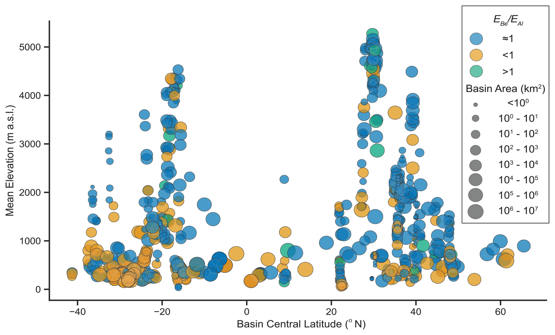
Figure 2Latitude and elevation distribution of basins in our compilation. Color-coding indicates if calculated erosion rate ratios are indistinguishable from 1 (considering 2σ analytical uncertainties), distinguishably lower than 1, or distinguishably higher than 1. The marker size indicates source basin area.
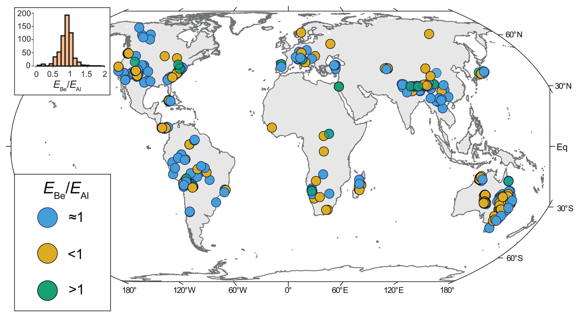
Figure 3Inset: distribution of values. Main: map of basin centroid locations color-coded by values.
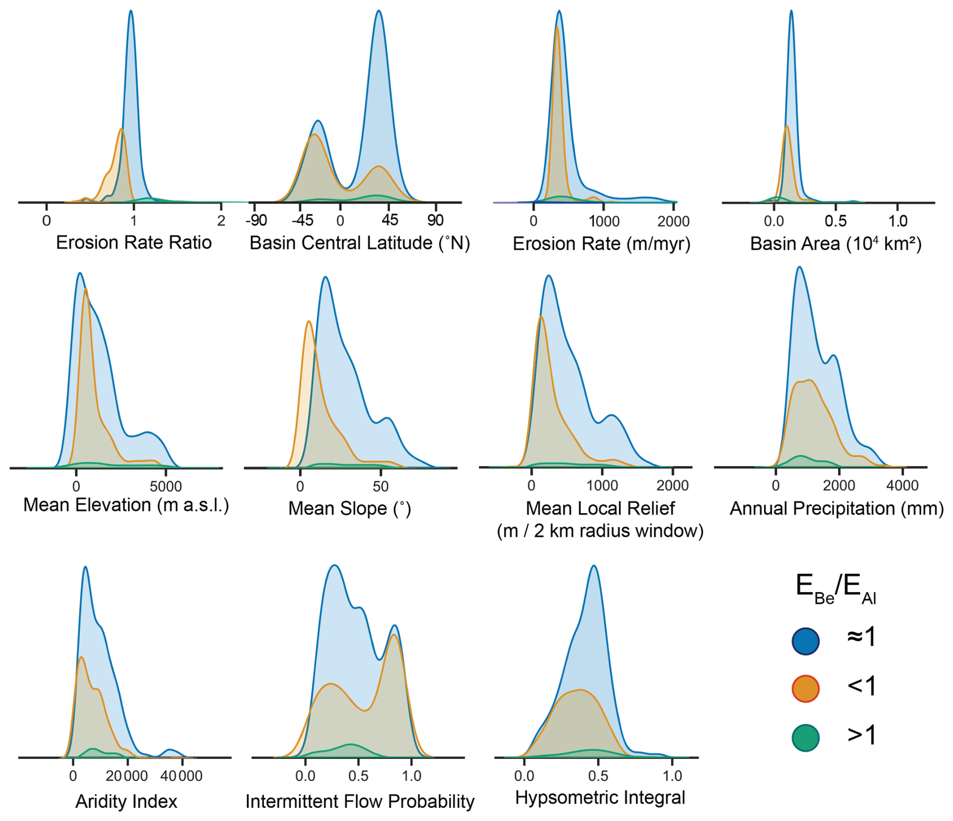
Figure 4Kernel density distributions of basin parameters with subdivision and color-coding based on values (see legend). Note that the erosion rate and basin area plots both feature extremely long tails on the high end and thus have x-axis limits imposed. Vertical axes on all plots are relative density values. Sources for all parameters and methods used in their calculations are provided in the Supplement.
The population of values (n=766) approximates a normal distribution with mean=0.88 and SD=0.21 (Fig. 3 inset). Approximately 31 % of the samples in the compilation (n=238) have values that are distinguishably lower than 1 when considering 2σ analytical uncertainties, while ∼3.5 % of samples (n=27) have values distinguishably higher than 1.
4.2 Correlation analysis and stepwise regression
Of the basin parameters, all but aridity index exhibit statistically significant correlations with values (p<0.05), although none of the correlations with are particularly strong (rs<0.4; Fig. 5).
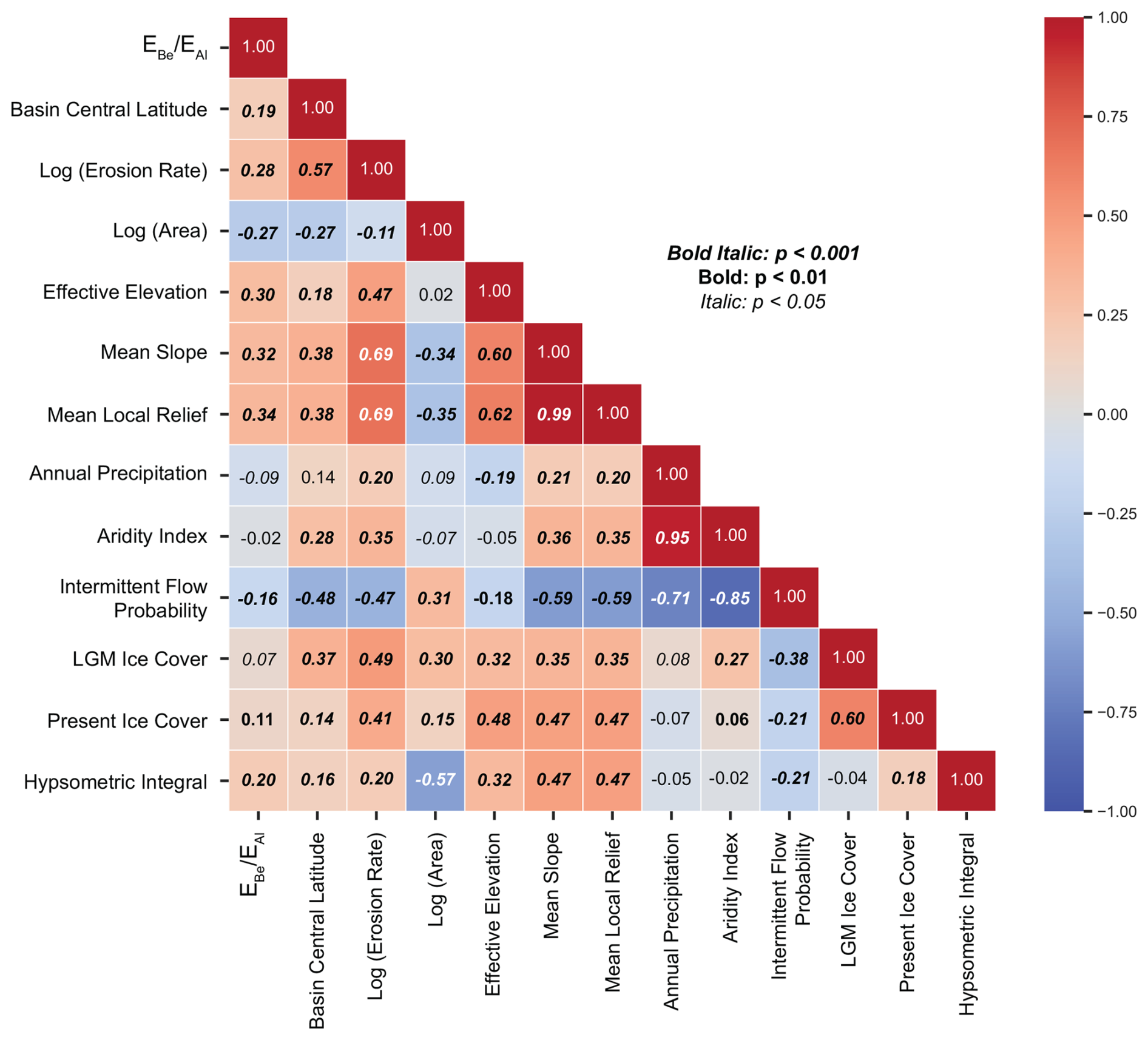
Figure 5Cross-correlation matrix for basin parameters and values. The color scale shows Spearman's correlation coefficient values, and the font styling indicates the statistical significance (p value) of the correlation coefficient.
The best-fitting linear model from the forward stepwise regression analysis (Table 1) predicts a decrease in values with increasing basin area, decreasing basin-averaged erosion rate, decreasing basin mean elevation, and decreasing hypsometric integral. No other basin parameters improved this multivariate model; thus those parameters were removed during the stepwise regression analysis. This model represents a statistically significant improvement over a constant model (p≪0.001), although a low reduced chi-squared statistic (0.048) suggests that it may overfit the data.
Table 1Summary of linear model () output from forward stepwise regression analysis.
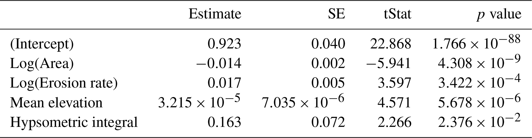
Number of observations: 765. Error degrees of freedom: 760,
Root-mean-square error: 0.207. R-squared: 0.111. Adjusted R-squared: 0.107.
F statistic vs. constant model: 23.8. p value =
Reduced chi-squared: 0.048.
4.3 ANOVA testing
ANOVA testing offers more granular insight into the decline of values with increasing basin area and decreasing hypsometric integral, and, among categorical basin parameters, it suggests that tectonic activity, but not dominant lithology, has a significant correlation with measured values (Fig. 6). Post hoc tests using group mean and median values produced nearly identical results; mean tests are shown here, while the results from median post hoc tests are included in the Supplement.
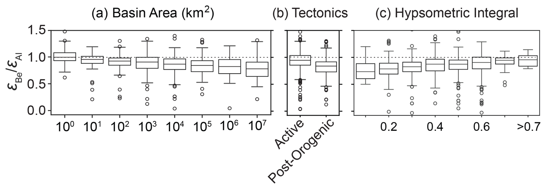
Figure 6One-way ANOVA results comparing values between basin area categories (a, basins in each category have areas less than or equal to the label on the x axis), basin tectonic activity (b), and dominant basin lithology (c). In each plot, boxes show median (center line) and 25th and 75th percentile values (box edges) and the maximum and minimum non-outlier values (whiskers). values plotted as circles are considered outliers (more than 1.5× the interquartile range). The dashed horizontal line in all plots is a reference line for . Note that n=8 samples have and are cropped out of this figure.
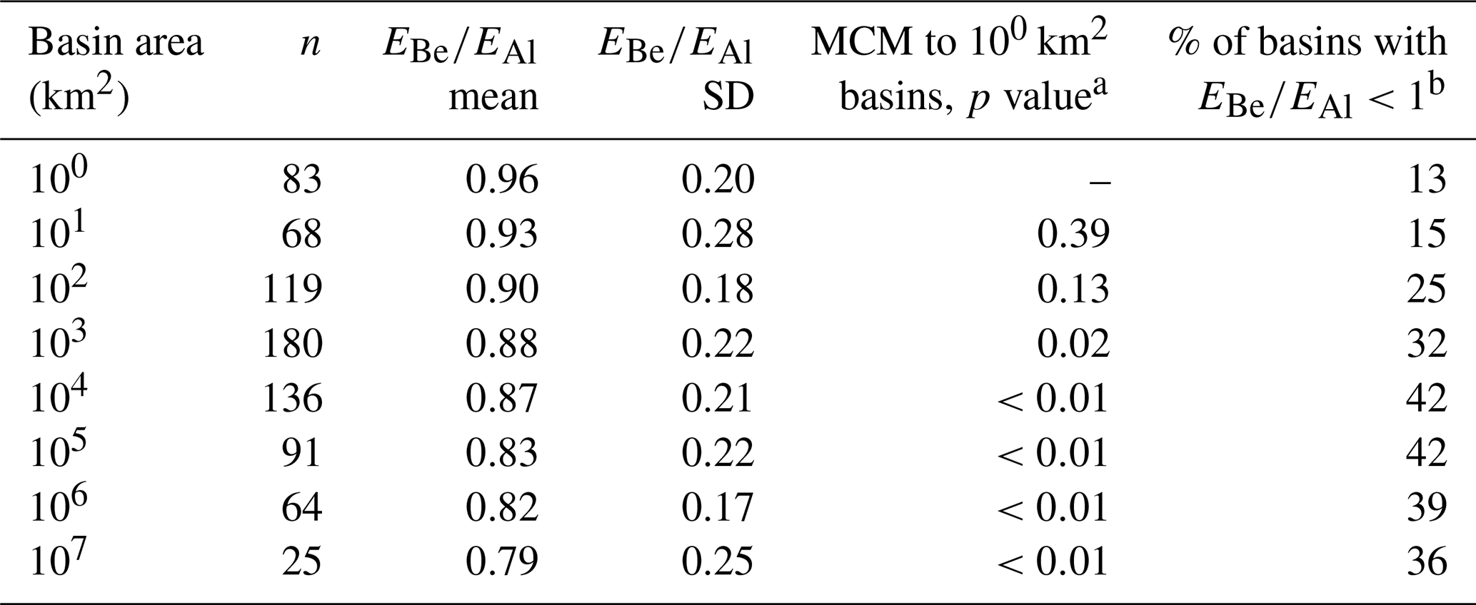
With basin areas binned on a logarithmic base-10 scale, a decline in values with increasing basin area is clear (Fig. 6; Table 2). Very small basins (≤1 km2) have a mean value of approximately 1 (μ=0.96 ± 0.20, n=83) while the largest basins (>1 000 000 km2) have a mean value of 0.79 ± 0.25 (n=25). We use a multi-comparison test to assess if mean values for each basin area category are significantly different than the smallest basin group and find that basins larger than 1000 km2 have mean values less than 1. The percentage of basins with values that are lower than 1 (considering 2σ uncertainties) increases from 13 % in the <1 km2 area bin to 40 % in the 104 km2 area bin and remains above 35 % for all larger basins (Table 2).
Table 2One-way ANOVA results comparing measured values between basin area categories. Note that the label for each basin area category shows the upper limit for basin areas in that bin.
a Shows p value for Tukey multi-comparison of means test performed between basin area category and the smallest basins (<100 km2).
b Including 2σ uncertainties.
Basin hypsometric integrals also have a statistically significant influence on based on ANOVA testing (Fig. 6; p=0.007). Mature basins with low hypsometric integrals generally have lower mean values compared to basins with high hypsometric integrals, but a multi comparison of means test demonstrates that these differences are not statistically significant (Table 3). The percentage of basins with values that are lower than 1 (considering 2σ uncertainties) increases from 9 % in the >0.7 hypsometric integral bin to >30 % for basins with hypsometric integrals <0.4 (Table 3).
Table 3One-way ANOVA results comparing measured values between hypsometric integral categories. Note that the label for each hypsometric integral category shows the upper limit for the integral in that bin.
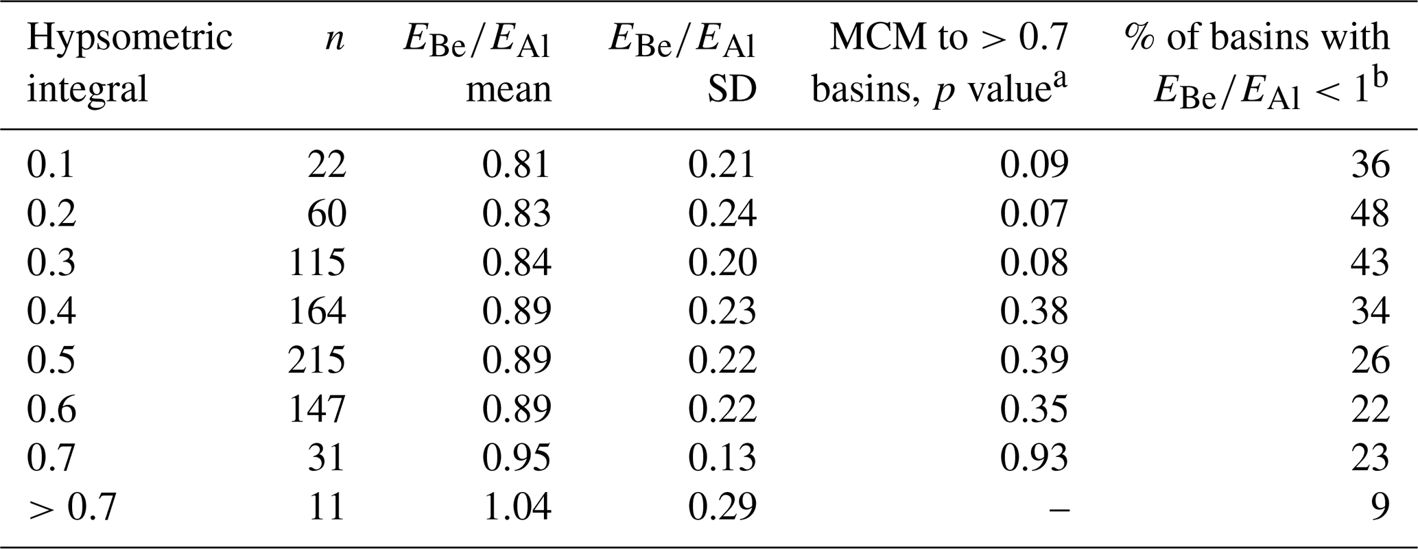
a Shows p value for Tukey multi-comparison of means test performed between hypsometric integral category and the category >0.7.
b Including 2σ uncertainties.
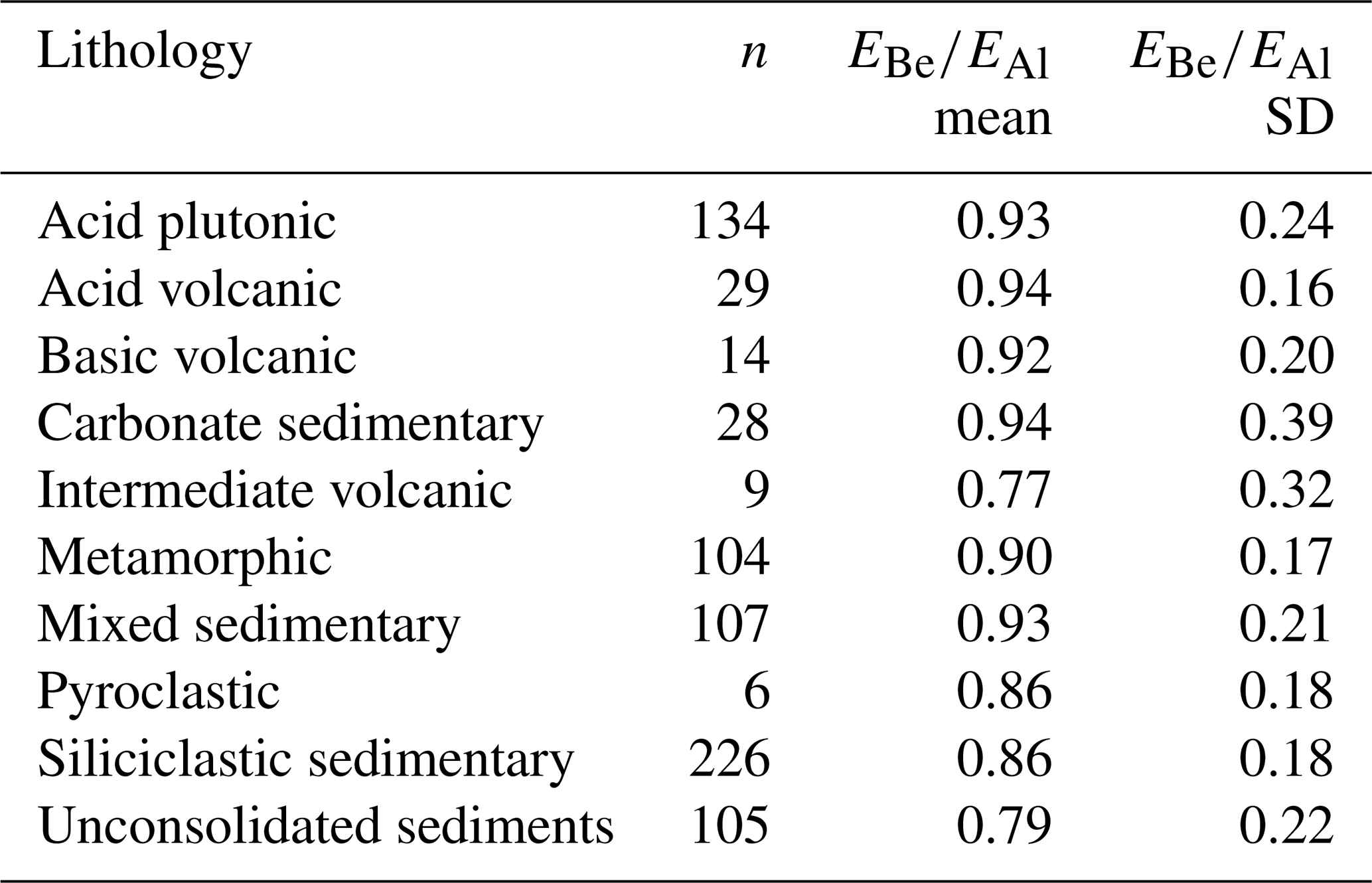
We find that basins in tectonically active settings have higher values (μ=0.93 ± 0.22, n=411) than post-orogenic basins (μ=0.83 ± 0.20, n=355); this difference is statistically significant (p≪0.01). Dominant basin lithology has less influence on values (Table 4). Most lithologies have mean values that are statistically indistinguishable from each other. The exception is basins composed primarily of unconsolidated sediments, which have, on average, lower values than other lithologies (μ=0.79 ± 0.22, n=105). The presence of glacial deposits in basins, categorized here as basins with more than 10 % coverage by Last Glacial Maximum ice (Ehlers et al., 2011), appears to have little influence on erosion rate discordance when considered at this global scale; basins containing glacial deposits have an average value (μ=0.90 ± 0.25, n=117) indistinguishable from those without glacial deposits (μ=0.88 ± 0.21, n=649).
Table 4Mean values and standard deviations for dominant basin lithologies as defined in the GLiM database (Hartmann and Moosdorf, 2012).
5.1 Prevalence and potential mechanisms causing complex sediment histories
We find widespread evidence of sediment histories that likely include extended sediment storage on timescales of 105–106 years, as indicated by values distinguishably lower than 1 (considering 2σ analytical uncertainties), in over 30 % of sampled basins around the world (n=238). This substantial number of low values rejects the null hypothesis (p≪0.001) of minimal nuclide decay due to sediment storage that is assumed in many single-nuclide erosion rate studies.
The occurrence and magnitude of depressed values is correlated with several basin morphological parameters, suggesting a systematic and thus predictable relationship between basin morphology and sediment history. Although most physical basin parameters exhibited statistically significant correlations with measured values (Fig. 2), widespread cross-correlations exist between these parameters and suggest several basin characteristics considered together are more likely to predict sediment histories including extended burial. The number of values distinguishably higher than 1 (n=27) is within the range expected due to Poisson-distributed measurement uncertainties and is not statistically significant (p≫0.05).
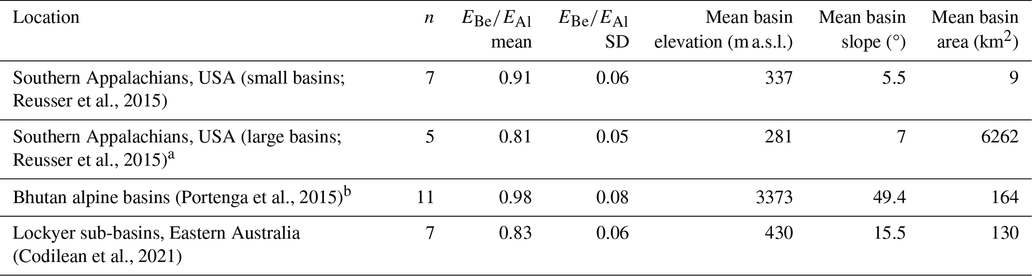
Stepwise linear regression and ANOVA testing suggests that basin area has the single largest influence on values (Figs. 5 and 6, Tables 1 and 2). The scaling of sediment storage duration with basin area is expected (Pizzuto, 2020), with extended burial leading to significant 26Al decay previously documented in very large basins (Wittmann et al., 2011, 2020). Here we find that the average value is lower than 1, implying >100 000 years of subsurface sediment storage, in basins as small as 1000–10 000 km2 (p=0.02). The influence of basin area is apparent in the southern Appalachian mountains of the United States (Reusser et al., 2015; Table 5), where large (>1000 km2, n=5) basins have a lower average value (0.81 ± 0.05) than small basins (<30 km2, n=7, ± 0.06, p=0.017), despite other physical basin parameters being similar.
Table 5 regional case studies.
a One outlier with was removed. The low ratio of this sample was attributed to laboratory error in the source publication.
b For this comparison, we removed basins larger than 1000 km2 (n=3).
Extended sediment storage in basins as small as 1000 km2 is inconsistent with scaling frameworks that relate sediment storage duration to floodplain area in meandering river systems (e.g., Lauer and Parker, 2008). This suggests other mechanisms facilitate extended sediment burial and re-introduction into the active channel. In such moderately sized basins, a variety of processes could explain extended sediment storage, including rivers cutting into sand dunes containing long-buried sediments (Eccleshall, 2019; Vermeesch et al., 2010), hydrologically variable basins where flood events remobilize vertically accreted floodplain deposits (Codilean et al., 2021), and excavation of deeply buried terrace sediments by outburst floods (Zhang et al., 2021). In source generation zones, particularly on slowly eroding hillslopes, deep vertical mixing can cause repeated burial on slopes, leading to differential nuclide decay before sediments enter river systems (Makhubela et al., 2019).
Other physical basin parameters play secondary and interlinked roles in determining erosion rate discordance (Fig. 5, Table 1). Mean basin slope and elevation are positively correlated with each other and with values, suggesting that alpine basins – which are typically steeper than lowland basins – produce fluvial sediment that has experienced minimal storage and burial. Similarly, basin-averaged erosion rates and intermittent river flow probability exhibit significant correlations with values and are negatively correlated to each other, suggesting that slowly eroding basins that regularly experience intermittent river flow are conducive to sediment storage and burial. The influence of basin slope, elevation, and tectonic activity is observed when comparing basins of similar areas in high-alpine Bhutan (Portenga et al., 2015) and low-lying eastern Australia (Codilean et al., 2021); the Bhutan basins have values near 1 (0.98 ± 0.06, n=11) while the eastern Australian basins have lower average values (0.83 ± 0.06, n=7, p<0.001), indicating extensive sediment storage (Table 5).
Based on cross-correlations between physical basin parameters, we conclude that sediment sourced from large lowland basins – particularly those over 1000 km2, with low average erosion rates, with low mean slopes, with high hypsometric integrals, and in post-orogenic settings – is more likely to exhibit erosion rate discordance indicative of sediment storage and burial in source and/or transfer zones. Smaller alpine basins, particularly steeper basins with higher average erosion rates in tectonically active regions, are more likely to produce sediment with values that overlap with 1 (within analytical uncertainties of 2 standard deviation), suggesting shorter and shallower sediment storage (<105 years). We infer that this is because larger, more gently sloping basins in tectonically quiescent regions offer more opportunities for extended sediment storage in floodplains.
Climatological variables play only a minor role in the occurrence and magnitude of erosion rate discordance. We found very weak correlations between mean annual precipitation and aridity (Fig. 5; Table 1). However, intermittent flow probability exhibited a significant negative correlation to values (Fig. 5), suggesting that basins with a higher probability of discontinuous flow for at least 1 d per year are more likely to contain sediment with an extended history of burial. While fluvial systems that experience intermittent flow are most common in arid and semiarid regions (Costigan et al., 2017), they exist around the world, and intermittent flow probability is correlated with a variety of hydrologic, geologic, and morphologic variables in addition to climate regime (Messager et al., 2021; Fig. 6). Therefore, we cannot confidently attribute an exclusively climatological root for the correlation between intermittent flow probability and isotopic evidence of sediment burial.
Both low and high values can be caused by laboratory uncertainty (statistical measurement uncertainty) and biases (inaccurate measurements) that influence measured nuclide concentrations. Critical to the accuracy of 26Al and 10Be measurements by AMS is the quantification of total aluminum and beryllium in samples (the stable isotopes 27Al and 9Be, which are many orders of magnitude greater in concentration that the radionuclides 26Al and 10Be). Native beryllium at detectable levels in quartz is rare but occasionally present (e.g., Portenga et al., 2015), and not all laboratories quantify total Be in samples. Unaccounted-for native 9Be will lower measured ratios, lower calculated 10Be concentrations, and increase calculated ratios.
The presence of meteoric (atmospherically derived) 10Be, if not completely removed by the quartz purification process (Kohl and Nishiizumi, 1992), will increase measured concentration of in situ 10Be as shown by Corbett et al. (2021). In such cases, its presence lowers measured ratios (Corbett et al., 2022; Moon et al., 2018). Given sediment storage and thus extended residence and weathering times in large basins, the persistence of weathered mafic minerals is more likely in smaller basins, where sediment has less time to weather during transport.
Conversely, stable aluminum (27Al) is ubiquitous in quartz, meaning that full retention and accurate measurement of that isotope, typically via inductively coupled plasma optical emission spectroscopy (ICP-OES) after quartz dissolution (e.g., Corbett et al., 2016), are critical to properly quantifying the concentration of 26Al. Low recovery of total Al before ICP-OES and the presence of AlF complexes in ICP solutions result in lower ratios than in reality (Bierman and Caffee, 2002; Corbett et al., 2016). While some scatter in the data is likely the result of such laboratory errors, the observed systematic correlations between morphological basin parameters and values suggest that most low ratios are due to geologic, rather than laboratory, processes.
5.2 Implications for cosmogenically derived erosion rates and understanding landscapes
Our analysis shows that nearly one-third of all samples for which multi-nuclide measurements exist have discordance between erosion rates derived from 10Be and 26Al beyond 2σ uncertainty. Although some discordant samples may be the result of laboratory errors, most of them likely represent the complex history of sediment in drainage basins. Because our regression analysis shows that large, low-slope basins with low erosion rates are most likely to have sediment with discordant 10Be- and 26Al-derived erosion rates, such complexity is best explained by extended sediment storage (>105 years) in low-gradient floodplains typical of such basins – sufficient time for the decay of 26Al to be reliably measurable (e.g., Wittmann et al., 2011; Wittmann and von Blanckenburg, 2016). However, we also find such discordance in basins as small as 1000 km2, demonstrating that extended sediment storage followed by re-entry into active channels occurs in a variety of fluvial settings in addition to large, meandering, low-land river systems.
The impact of sediment storage on the veracity of cosmogenically determined erosion rates is difficult to assess for several reasons. Firstly, sediment samples are a mixture of material, meaning that every sample contains many thousands of sand grains, each of which has its own idiosyncratic history. Such mixing means that any attempt at decay correction will be inaccurate, as mixing is a linear process and decay correction is not (Bierman and Steig, 1996). Secondly, sediment both loses nuclides (through radio-decay) and gains nuclides (by production at depth, dominated by muons) while in storage. The resulting nuclide concentration is a convolution of time and depth in storage, where depth is unlikely to be constant through time. Because 10Be has a half-life of 1.4 Myr, it behaves similarly to a stable isotope on timescales typically of concern to geomorphologists, between 105–106 years. Thus, while low suggests sediment storage on these timescales, it need not imply that 10Be-derived erosion rates are biased significantly by radio-decay.
We regard in fluvial sediment samples as a window into watershed processes. Specifically, measuring multiple nuclides in sediment samples is useful for detecting sediment storage. Additional field and remote sensing measurements, not now typically done alongside sampling for cosmogenic nuclides, have the potential to better elucidate the processes lowering and the interpretation of measured ratios. For example, field and remote sensing data could be used to estimate both the volume and the depth of sediment in storage on lowland floodplains (e.g., Dunne et al., 1998), whereas depth profiles along cut banks and in drill cores could provide quantification of nuclide concentrations in material stored in floodplains with depth (Bierman et al., 2005). Measuring cosmogenic nuclides in samples collected down drainage networks can demonstrate if nuclide activities and ratios change with basin area and average slope (Clapp et al., 2002; Reusser et al., 2017). Together, these data will elucidate landscape behavior at a variety of scales and bring a deeper understanding of sediment routing and erosion rates throughout large drainage basis.
The discordance between basin-averaged erosion rates derived from in situ cosmogenic 10Be and 26Al in detrital fluvial samples provides insights into geomorphic controls on sediment sourcing and routing dynamics and a valuable check on the assumption of minimal sediment storage that is central to the widely used single-nuclide erosion rate method. We calculated the ratio between 10Be- and 26Al-derived erosion rates () in a global compilation of detrital fluvial samples with measurements from both nuclides (n=766, of which n=117 are new) and found that nearly one-third of the samples (n=238) exhibit erosion rate discordance as indicated by (beyond the bounds of 2σ analytical uncertainties). Low values in detrital sediments are most likely the result of 26Al decay during extended storage (>105 years) on hillslopes or in fluvial networks. Source basin area has the greatest influence on sediment values, with basins >1000 km2 more likely to contain sediment with significantly less than 1. Other physical basin parameters have secondary and interlinked correlations to , allowing us to separate basins into two broad categories. Large, low-slope lowland basins in post-orogenic settings are more likely to produce sediment exhibiting erosion rate discordance indicative of extended sediment storage (>105 years). Smaller (<1000 km2) steep alpine basins in tectonically active settings are more likely to produce sediment exhibiting erosion rate agreement indicative of minimal sediment storage (<105 years). These results provide global-scale insights into sediment routing system dynamics and demonstrate the utility of a multi-nuclide approach for understanding geomorphic processes at the scale of drainage basins.
The supplementary information for this study, including supplementary data tables, text, a Jupyter Notebook, and MATLAB script containing code for the statistical analyses and figure production, is available on public GitHub and Zenodo repositories and can be found at https://doi.org/10.5281/zenodo.15839165 (Halsted, 2025).
The supplement related to this article is available online at https://doi.org/10.5194/gchron-7-213-2025-supplement.
PRB and LBC conceptualized the study and acquired funding, while CTH conducted the investigation. PRB and LBC provided laboratory resources for cosmogenic nuclide chemical processing, and LBC supervised CTH while he performed the chemistry procedures. MWC performed 26Al measurements and assisted with the interpretation of results. CTH and ATC were responsible for compiling previously published nuclide measurements and performing geospatial analyses, while CTH performed the statistical analyses. CTH prepared all data visualizations and prepared the original draft of the article. CTH, PRB, LBC, ATC, and MWC worked together to review and edit drafts, and all agreed on the final draft for journal submission.
The contact author has declared that none of the authors has any competing interests.
Publisher's note: Copernicus Publications remains neutral with regard to jurisdictional claims made in the text, published maps, institutional affiliations, or any other geographical representation in this paper. While Copernicus Publications makes every effort to include appropriate place names, the final responsibility lies with the authors.
We thank Hella Wittmann for providing constructive feedback as handling editor and Regis Braucher and Timothée Jautzy as reviewers. We thank Greg Balco for constructive discussions during the developmental stages of this project.
This research has been supported by the Directorate for Geosciences, Division of Earth Sciences (grant no. 1733887).
This paper was edited by Hella Wittmann and reviewed by Regis Braucher and Timothée Jautzy.
Abdi, H. and Williams, L. J.: Tukey's Honestly Significant Difference (HSD) Test, in: Encyclopedia of Research Design, edited by: Salkind, N. J. and Frey, B. B., Sage, Thousand Oaks, CA, 1–5, ISBN 978-1-4129-6127-1, https://doi.org/10.4135/9781412961288.n278, 2010.
Allen, P. A.: Time scales of tectonic landscapes and their sediment routing systems, Geological Society, London, Special Publications, 296, 7–28, 2008.
Allen, P. A.: Sediment Routing Systems: The Fate of Sediment from Source to Sink, Cambridge University Press, Cambridge, https://doi.org/10.1017/9781316135754, 2017.
Argento, D. C., Stone, J. O., Reedy, R. C., and O'Brien, K.: Physics-based modeling of cosmogenic nuclides part II – Key aspects of in-situ cosmogenic nuclide production, Quat. Geochronol., 26, 44–55, https://doi.org/10.1016/j.quageo.2014.09.005, 2015.
Balco, G. and Rovey, C. W.: An isochron method for cosmogenic-nuclide dating of buried soils and sediments, Am. J. Sci., 308, 1083–1114, https://doi.org/10.2475/10.2008.02, 2008.
Balco, G., Stone, J. O., Lifton, N. A., and Dunai, T. J.: A complete and easily accessible means of calculating surface exposure ages or erosion rates from 10Be and 26Al measurements, Quat. Geochronol., 3, 174–195, https://doi.org/10.1016/j.quageo.2007.12.001, 2008.
Ben-Israel, M., Armon, M., Team, A., and Matmon, A.: Sediment residence times in large rivers quantified using a cosmogenic nuclides based transport model and implications for buffering of continental erosion signals, J. Geophys. Res.-Earth, 127, e2021JF006417, https://doi.org/10.1029/2021JF006417, 2022.
Bierman, P. and Caffee, M.: Cosmogenic exposure and erosion history of Australian bedrock landforms, Geol. Soc. Am. Bull., 114, 787–803, https://doi.org/10.1130/0016-7606(2002)114<0787:CEAEHO>2.0.CO;2, 2002.
Bierman, P. and Steig, E. J.: Estimating rates of denudation using cosmogenic isotope abundances in sediment, Earth Surf. Proc. Land., 21, 125–139, https://doi.org/10.1002/(SICI)1096-9837(199602)21:2<125::AID-ESP511>3.0.CO;2-8, 1996.
Bierman, P., Clapp, E., Nichols, K., Gillespie, A., and Caffee, M. W.: Using cosmogenic nuclide measurements in sediments to understand background rates of erosion and sediment transport, in: Landscape Erosion and Evolution Modeling, edited by: Harmon, R. S. and Doe, W. W., Springer, 89–115, https://doi.org/10.1007/978-1-4615-0575-4_5, 2001.
Bierman, P. R. and Caffee, M.: Slow Rates of Rock Surface Erosion and Sediment Production Across the Namib Desert and Escarpment, Southern Africa, Am. J. Sci., 301, 326–358, https://doi.org/10.2475/ajs.301.4-5.326, 2001.
Bierman, P. R. and Nichols, K. K.: Rock to sediment – slope to sea with 10Be – rates of landscape change, Annu. Rev. Earth Pl. Sc., 32, 215–255, 2004.
Bierman, P. R., Reuter, J. M., Pavich, M., Gellis, A. C., Caffee, M. W., and Larsen, J.: Using cosmogenic nuclides to contrast rates of erosion and sediment yield in a semi-arid, arroyo-dominated landscape, Rio Puerco Basin, New Mexico, Earth Surf. Proc. Land., 30, 935–953, https://doi.org/10.1002/esp.1255, 2005.
Blöthe, J. H. and Korup, O.: Millennial lag times in the Himalayan sediment routing system, Earth Planet. Sc. Lett., 382, 38–46, 2013.
Brown, E. T., Stallard, R. F., Larsen, M. C., Raisbeck, G. M., and Yiou, F.: Denudation rates determined from the accumulation of in situ-produced 10Be in the Luquillo Experimental Forest, Puerto Rico, Earth Planet. Sc. Lett., 129, 193–202, 1995.
Campbell, M. K., Bierman, P. R., Schmidt, A. H., Sibello Hernández, R., García-Moya, A., Corbett, L. B., Hidy, A. J., Cartas Águila, H., Guillén Arruebarrena, A., Balco, G., Dethier, D., and Caffee, M.: Cosmogenic nuclide and solute flux data from central Cuban rivers emphasize the importance of both physical and chemical mass loss from tropical landscapes, Geochronology, 4, 435–453, https://doi.org/10.5194/gchron-4-435-2022, 2022.
Carretier, S., Guerit, L., Harries, R., Regard, V., Maffre, P., and Bonnet, S.: The distribution of sediment residence times at the foot of mountains and its implications for proxies recorded in sedimentary basins, Earth Planet. Sc. Lett., 546, 116448, https://doi.org/10.1016/j.epsl.2020.116448, 2020.
Cazes, G., Fink, D., Codilean, A. T., Fülöp, R., Fujioka, T., and Wilcken, K. M.: ratios reveal the source of river sediments in the Kimberley, NW Australia, Earth Surf. Proc. Land., 45, 424–439, 2020.
Chmeleff, J., Von Blanckenburg, F., Kossert, K., and Jakob, D.: Determination of the 10Be half-life by multicollector ICP-MS and liquid scintillation counting, Nucl. Instrum. Meth. B, 268, 192–199, https://doi.org/10.1016/j.nimb.2009.09.012, 2010.
Clapp, E. M., Bierman, P. R., Schick, A. P., Lekach, J., Enzel, Y., and Caffee, M.: Sediment yield exceeds sediment production in arid region drainage basins, Geology, 28, 995–998, https://doi.org/10.1130/0091-7613(2000)28<995:SYESPI>2.0.CO;2, 2000.
Clapp, E. M., Bierman, P. R., Nichols, K. K., Pavich, M., and Caffee, M.: Rates of sediment supply to arroyos from upland erosion determined using in situ produced cosmogenic 10Be and 26Al, Quaternary Res., 55, 235–245, https://doi.org/10.1006/qres.2000.2211, 2001.
Clapp, E. M., Bierman, P. R., and Caffee, M.: Using 10Be and 26Al to determine sediment generation rates and identify sediment source areas in an arid region drainage basin, Geomorphology, 45, 89–104, https://doi.org/10.1016/s0169-555x(01)00191-x, 2002.
Codilean, A. T. and Munack, H.: Short communication: Updated CRN Denudation collections in OCTOPUS v2.3, Geochronology, 7, 113–122, https://doi.org/10.5194/gchron-7-113-2025, 2025.
Codilean, A. T. and Sadler, P. M.: Tectonic Controls on Himalayan Denudation?, AGU Advances, 2, e2021AV000539, https://doi.org/10.1029/2021AV000539, 2021.
Codilean, A. T., Munack, H., Cohen, T. J., Saktura, W. M., Gray, A., and Mudd, S. M.: OCTOPUS: an open cosmogenic isotope and luminescence database, Earth Syst. Sci. Data, 10, 2123–2139, https://doi.org/10.5194/essd-10-2123-2018, 2018.
Codilean, A. T., Fülöp, R.-H., Munack, H., Wilcken, K. M., Cohen, T. J., Rood, D. H., Fink, D., Bartley, R., Croke, J., and Fifield, L.: Controls on denudation along the East Australian continental margin, Earth-Sci. Rev., 214, 103543, https://doi.org/10.1016/j.earscirev.2021.103543, 2021.
Codilean, A. T., Munack, H., Saktura, W. M., Cohen, T. J., Jacobs, Z., Ulm, S., Hesse, P. P., Heyman, J., Peters, K. J., Williams, A. N., Saktura, R. B. K., Rui, X., Chishiro-Dennelly, K., and Panta, A.: OCTOPUS database (v.2), Earth Syst. Sci. Data, 14, 3695–3713, https://doi.org/10.5194/essd-14-3695-2022, 2022.
Corbett, L. B., Bierman, P. R., and Rood, D. H.: An approach for optimizing in situ cosmogenic 10Be sample preparation, Quat. Geochronol., 33, 24–34, https://doi.org/10.1016/j.quageo.2016.02.001, 2016.
Corbett, L. B., Bierman, P. R., Brown, T. A., Caffee, M. W., Fink, D., Freeman, S. P. H. T., Hidy, A. J., Rood, D. H., Wilcken, K. M., and Woodruff, T. E.: Clean quartz matters for cosmogenic nuclide analyses: An exploration of the importance of sample purity using the CRONUS-N reference material, Quat. Geochronol., 73, 101403, https://doi.org/10.1016/j.quageo.2022.101403, 2022.
Dosseto, A., Buss, H. L., and Chabaux, F.: Age and weathering rate of sediments in small catchments: The role of hillslope erosion, Geochim. Cosmochim. Ac., 132, 238–258, https://doi.org/10.1016/j.gca.2014.02.010, 2014.
Dunne, T., Mertes, L. A. K., Meade, R. H., Richey, J. E., and Forsberg, B. R.: Exchanges of sediment between the flood plain and channel of the Amazon River in Brazil, GSA Bulletin, 110, 450–467, https://doi.org/10.1130/0016-7606(1998)110<0450:EOSBTF>2.3.CO;2, 1998.
Eccleshall, S. V.: The why, when, and where of anabranching rivers in the arid Lake Eyre Basin, Doctor of Philosophy thesis, University of Wollongong, https://doi.org/10.71747/uow-r3gk326m.28191749.v1, 2019.
Ehlers, J., Gibbard, P., and Hughes, P.: Quaternary Glaciations – Extent and Chronology, edited by: Rose, J., Elsevier, 2–1108, ISBN 978-0-444-53447-7, 2011.
Fülöp, R.-H., Codilean, A. T., Wilcken, K. M., Cohen, T. J., Fink, D., Smith, A. M., Yang, B., Levchenko, V. A., Wacker, L., and Marx, S. K.: Million-year lag times in a post-orogenic sediment conveyor, Science Advances, 6, eaaz8845, https://doi.org/10.1126/sciadv.eaaz8845, 2020.
Granger, D. E.: A review of burial dating methods using 26Al and 10Be, in: In Situ-Produced Cosmogenic Nuclides and Quantification of Geological Processes: Geological Society of America Special Paper 415, edited by: Siame, L. L., Bourles, D. L., and Brown, E. T., Geological Society of America, 1–16, https://doi.org/10.1130/2006.2415(01), 2006.
Granger, D. E. and Schaller, M.: Cosmogenic Nuclides and Erosion at the Watershed Scale, Elements, 10, 369–373, https://doi.org/10.2113/gselements.10.5.369, 2014.
Granger, D. E., Kirchner, J. W., and Finkel, R.: Spatially averaged long-term erosion rates measured from in situ-produced cosmogenic nuclides in alluvial sediment, J. Geol., 104, 249–257, https://doi.org/10.1086/629823, 1996.
Halsted, C.: halstedct/fluvial_ratios: Post-review revisions (v2.0), Zenodo [code and data set], https://doi.org/10.5281/zenodo.15839165, 2025.
Halsted, C. T., Bierman, P. R., and Balco, G.: Empirical Evidence for Latitude and Altitude Variation of the In Situ Cosmogenic Production Ratio, Geosciences, 11, 402, https://doi.org/10.3390/geosciences11100402, 2021.
Hartmann, J. and Moosdorf, N.: The new global lithological map database GLiM: A representation of rock properties at the Earth surface, Geochem. Geophy. Geosy., 13, Q12004, https://doi.org/10.1029/2012GC004370, 2012.
Heimsath, A. M., Dietrich, W. E., Nishiizumi, K., and Finkel, R. C.: The soil production function and landscape equilibrium, Nature, 388, 358–361, 1997.
Hidy, A. J., Gosse, J. C., Blum, M. D., and Gibling, M. R.: Glacial–interglacial variation in denudation rates from interior Texas, USA, established with cosmogenic nuclides, Earth Planet. Sc. Lett., 390, 209–221, 2014.
Jautzy, T., Rixhon, G., Braucher, R., Delunel, R., Valla, P. G., Schmitt, L., and Team, A.: Cosmogenic (un-)steadiness revealed by paired-nuclide catchment-wide denudation rates in the formerly half-glaciated Vosges Mountains (NE France), Earth Planet. Sc. Lett., 625, 118490, https://doi.org/10.1016/j.epsl.2023.118490, 2024.
Jerolmack, D. J. and Paola, C.: Shredding of environmental signals by sediment transport, Geophys. Res. Lett., 37, L19401, https://doi.org/10.1029/2010GL044638, 2010.
Jonell, T. N., Owen, L. A., Carter, A., Schwenniger, J.-L., and Clift, P. D.: Quantifying episodic erosion and transient storage on the western margin of the Tibetan Plateau, upper Indus River, Quaternary Res., 89, 281–306, https://doi.org/10.1017/qua.2017.92, 2018.
Jungers, M. C., Bierman, P. R., Matmon, A., Nichols, K., Larsen, J., and Finkel, R.: Tracing hillslope sediment production and transport with in situ and meteoric 10Be, J. Geophys. Res.-Earth, 114, F04020, https://doi.org/10.1029/2008JF001086, 2009.
Kober, F., Ivy-Ochs, S., Zeilinger, G., Schlunegger, F., Kubik, P., Baur, H., and Wieler, R.: Complex multiple cosmogenic nuclide concentration and histories in the arid Rio Lluta catchment, northern Chile, Earth Surf. Proc. Land., 34, 398–412, 2009.
Kohl, C. P. and Nishiizumi, K.: Chemical isolation of quartz for measurement of in-situ-produced cosmogenic nuclides, Geochim. Cosmochim. Ac., 56, 3583–3587, https://doi.org/10.1016/0016-7037(92)90401-4, 1992.
Korschinek, G., Bergmaier, A., Faestermann, T., Gerstmann, U. C., Knie, K., Rugel, G., Wallner, A., Dillmann, I., Dollinger, G., Lierse von Gostomski, C., Kossert, K., Maiti, M., Poutivtsev, M., and Remmert, A.: A new value for the half-life of 10Be by Heavy-Ion Elastic Recoil Detection and liquid scintillation counting, Nucl. Instrum. Meth. B, 268, 187–191, https://doi.org/10.1016/j.nimb.2009.09.020, 2010.
Lal, D.: Cosmic ray labeling of erosion surfaces: in situ nuclide production rates and erosion models, Earth Planet. Sc. Lett., 104, 424–439, https://doi.org/10.1016/0012-821x(91)90220-c, 1991.
Langbein, W. B. and Leopold, L. B.: Quasi-equilibrium states in channel morphology, Am. J. Sci., 262, 782–794, 1964.
Lauer, J. W. and Parker, G.: Modeling framework for sediment deposition, storage, and evacuation in the floodplain of a meandering river: Theory, Water Resour. Res., 44, W04425, https://doi.org/10.1029/2006WR005528, 2008.
Leopold, L. B. and Wolman, M. G.: River meanders, Geol. Soc. Am. Bull., 71, 769–793, 1960.
Lifton, N., Sato, T., and Dunai, T. J.: Scaling in situ cosmogenic nuclide production rates using analytical approximations to atmospheric cosmic-ray fluxes, Earth Planet. Sc. Lett., 386, 149–160, https://doi.org/10.1016/j.epsl.2013.10.052, 2014.
MacFarland, T. W. and Yates, J. M.: Kruskal–Wallis H-Test for Oneway Analysis of Variance (ANOVA) by Ranks, in: Introduction to Nonparametric Statistics for the Biological Sciences Using R, edited by: MacFarland, T. W. and Yates, J. M., Springer International Publishing, Cham, 177–211, https://doi.org/10.1007/978-3-319-30634-6_6, 2016.
Makhubela, T., Kramers, J., Scherler, D., Wittmann, H., Dirks, P., and Winkler, S.: Effects of long soil surface residence times on apparent cosmogenic nuclide denudation rates and burial ages in the Cradle of Humankind, South Africa, Earth Surf. Proc. Land., 44, 2968–2981, 2019.
Moon, S., Merritts, D., Snyder, N., Bierman, P., Sanquini, A., Fosdick, J., and Hilley, G.: Erosion of coastal drainages in the Mendocino Triple Junction region (MTJ), northern California, Earth Planet. Sc. Lett., 502, 156–165, 2018.
Munack, H., Blöthe, J. H., Fülöp, R. H., Codilean, A. T., Fink, D., and Korup, O.: Recycling of Pleistocene valley fills dominates 135 ka of sediment flux, upper Indus River, Quaternary Sci. Rev., 149, 122–134, https://doi.org/10.1016/j.quascirev.2016.07.030, 2016.
Nichols, K. K., Bierman, P. R., Hooke, R. L., Clapp, E. M., and Caffee, M.: Quantifying sediment transport on desert piedmonts using 10Be and 26Al, Geomorphology, 45, 105–125, https://doi.org/10.1016/S0169-555X(01)00192-1, 2002.
Nishiizumi, K.: Preparation of 26Al AMS standards, Nucl. Instrum. Meth. B, 223–224, 388–392, https://doi.org/10.1016/j.nimb.2004.04.075, 2004.
Nishiizumi, K., Imamura, M., Caffee, M. W., Southon, J. R., Finkel, R. C., and McAninch, J.: Absolute calibration of 10Be AMS standards, Nucl. Instrum. Meth. B, 258, 403–413, https://doi.org/10.1016/j.nimb.2007.01.297, 2007.
Otto, J., Schrott, L., Jaboyedoff, M., and Dikau, R.: Quantifying sediment storage in a high alpine valley (Turtmanntal, Switzerland), Earth Surf. Proc. Land., 34, 1726–1742, 2009.
Pizzuto, J.: Suspended sediment and contaminant routing with alluvial storage: New theory and applications, Geomorphology, 352, 106983, https://doi.org/10.1016/j.geomorph.2019.106983, 2020.
Portenga, E. W. and Bierman, P. R.: Understanding Earth's eroding surface with 10Be, GSA Today, 21, 4–10, https://doi.org/10.1130G111A.1, 2011.
Portenga, E. W., Bierman, P., Duncan, C., Corbett, L. B., Kehrwald, N. M., and Rood, D. H.: Erosion rates of the Bhutanese Himalaya determined using in situ-produced 10Be, Geomorphology, 233, 112–126, https://doi.org/10.1016/j.geomorph.2014.09.027, 2015.
Repasch, M., Wittmann, H., Scheingross, J. S., Sachse, D., Szupiany, R., Orfeo, O., Fuchs, M., and Hovius, N.: Sediment Transit Time and Floodplain Storage Dynamics in Alluvial Rivers Revealed by Meteoric 10Be, J. Geophys. Res.-Earth, 125, e2019JF005419, https://doi.org/10.1029/2019JF005419, 2020.
Reusser, L., Bierman, P., and Rood, D.: Quantifying human impacts on rates of erosion and sediment transport at a landscape scale, Geology, 43, 171–174, 2015.
Reusser, L. J., Bierman, P. R., Rizzo, D. M., Portenga, E. W., and Rood, D. H.: Characterizing landscape-scale erosion using 10Be in detrital fluvial sediment: Slope-based sampling strategy detects the effect of widespread dams, Water Resour. Res., 53, 4476–4486, https://doi.org/10.1002/2016WR019774, 2017.
Romans, B. W., Castelltort, S., Covault, J. A., Fildani, A., and Walsh, J.: Environmental signal propagation in sedimentary systems across timescales, Earth-Sci. Rev., 153, 7–29, 2016.
Schaefer, J. M., Codilean, A. T., Willenbring, J. K., Lu, Z.-T., Keisling, B., Fülöp, R.-H., and Val, P.: Cosmogenic nuclide techniques, Nature Reviews Methods Primers, 2, 18, https://doi.org/10.1038/s43586-022-00096-9, 2022.
Schumm, S.: The Fluvial System, John Wiley & Sons, New York, 338 pp., ISBN-10 0471019011, 1977.
Struck, M., Jansen, J. D., Fujioka, T., Codilean, A. T., Fink, D., Egholm, D. L., Fülöp, R.-H., Wilcken, K. M., and Kotevski, S.: Soil production and transport on postorogenic desert hillslopes quantified with 10Be and 26Al, GSA Bulletin, 130, 1017–1040, 2018.
Tofelde, S., Bernhardt, A., Guerit, L., and Romans, B. W.: Times Associated With Source-to-Sink Propagation of Environmental Signals During Landscape Transience, Front. Earth Sci., 9, 628315, https://doi.org/10.3389/feart.2021.628315, 2021.
VanLandingham, L. A., Portenga, E. W., Lefroy, E. C., Schmidt, A. H., Bierman, P. R., and Hidy, A. J.: Comparison of basin-scale in situ and meteoric 10Be erosion and denudation rates in felsic lithologies across an elevation gradient at the George River, northeast Tasmania, Australia, Geochronology, 4, 153–176, https://doi.org/10.5194/gchron-4-153-2022, 2022.
Vermeesch, P., Fenton, C., Kober, F., Wiggs, G., Bristow, C. S., and Xu, S.: Sand residence times of one million years in the Namib Sand Sea from cosmogenic nuclides, Nat. Geosci., 3, 862–865, 2010.
von Blanckenburg, F.: The control mechanisms of erosion and weathering at basin scale from cosmogenic nuclides in river sediment, Earth Planet. Sc. Lett., 237, 462–479, https://doi.org/10.1016/j.epsl.2005.06.030, 2005.
Willenbring, J. K., Codilean, A. T., and McElroy, B.: Earth is (mostly) flat: Apportionment of the flux of continental sediment over millennial time scales, Geology, 41, 343–346, https://doi.org/10.1130/g33918.1, 2013.
Wittmann, H. and von Blanckenburg, F.: Cosmogenic nuclide budgeting of floodplain sediment transfer, Geomorphology, 109, 246–256, 2009.
Wittmann, H. and von Blanckenburg, F.: The geological significance of cosmogenic nuclides in large lowland river basins, Earth-Sci. Rev., 159, 118–141, 2016.
Wittmann, H., von Blanckenburg, F., Maurice, L., Guyot, J. L., and Kubik, P. W.: Recycling of Amazon floodplain sediment quantified by cosmogenic 26Al and 10Be, Geology, 39, 467–470, https://doi.org/10.1130/g31829.1, 2011.
Wittmann, H., Malusà, M. G., Resentini, A., Garzanti, E., and Niedermann, S.: The cosmogenic record of mountain erosion transmitted across a foreland basin: Source-to-sink analysis of in situ 10Be, 26Al and 21Ne in sediment of the Po river catchment, Earth Planet. Sc. Lett., 452, 258–271, 2016.
Wittmann, H., Oelze, M., Gaillardet, J., Garzanti, E., and von Blanckenburg, F.: A global rate of denudation from cosmogenic nuclides in the Earth's largest rivers, Earth-Sci. Rev., 204, 103147, https://doi.org/10.1016/j.earscirev.2020.103147, 2020.
Zhang, X., Cui, L., Xu, S., Liu, C., Zhao, Z., Zhang, M., and Liu-Zeng, J.: Assessing non-steady-state erosion processes using paired 10Be–26Al in southeastern Tibet, Earth Surf. Proc. Land., 46, 1363–1374, 2021.